Hurricane Chart
1900-2004
Hurricane Trends
During the earliest part of the 21st century
Scientists in the quest to explain the increase in storms during the Atlantic hurricane season have proposed Atlantic Multidecadal Oscillation AMO. What is stated in various journals and published papers is that this cycle will last at least a decade. Is there any truth to the theory or are the basic facts compromised to back the story?
Record keeping for the past 100 years does not support the story, but few were counting on background research when the story was posted. The graph below, chart 1 supports that there are highs and lows in the number of storms over the last century, but these peaks of ideal conditions last only a few years at best. Peaks in total numbers of storms at 21 were set in the years of 1933, 1995, 2003 (1995 & 2003 included tropical depressions 30-39mph.), but the graph of Sea Surface Temperatures (SST) does not correlate the data with corresponding peaks preceding the events in chart 2. As a lay person not well verse in the sciences may say, who am I to believe?
First, lets look at trends. The scientists with media access in the
United States have concluded the 30 year cycle in the Atlantic Basin AMO, will yield an elevated amount of storms over the next decade according to records,
but they say more study is needed. With just a little research, chart analysis shows a
trough from the mid thirties to the early seventies a short spike then
another similar trough stretching to '95. Anyone can see that the spikes in
hurricane activity is short lived outside of the new trend of the late nineties,
thus the cycles do not last the predicted decades as stated in the story below. What needs to be looked at is
the trend of rising bottoms on chart 1, which shows that something has changed since 1995.
Scientists have stated "
Now lets examine the SST numbers.
The facts stated by the scientists of the
United States conclude there is any global warming trend or solid evidence to support the idea and I quote,
"Willoughby
said he is keeping an open mind about the role of global warming but believes it
won't be a factor for at least another 100 years.
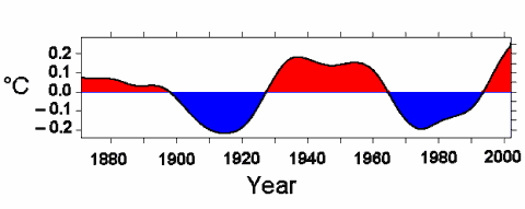
The technical name for the engine driving the hurricane cycles is the Atlantic Multidecadal Oscillation, or AMO for short. This is theory presented to the public in order to mold opinion matters in the recent upswing of violent storms which are supposed to be part of a cycle and what was normal will return in a few decades. First using the Atlantic basin as a guide for all of the Earth's climate captures only a microcosm of events that may reveal warming trend. The totals on chart 3 excludes the temperate oceans while only the arctic waters are excluded from NOAA chart 2, which shows a completely different trend from chart 3 AMO. It starts with a slow descent in SST in chart 2 from 1850 to 1908 then a steady rise to about the year 1996 followed by a sharp breakout. The oceans which mix and warm or cool slowly does not back the theory of AMO as one can see by comparing the charts. Hurricane activity only spiked for a few years in the past, not decades as quoted now in the media. So where did the information placed in the news reports have its origins and why? Not from the official sources of the NOAA and there is much speculation around the word 'why'. Then the next assumption "when the tropical storm activity is high. It also results in ample rainfall, making the ocean water less salty. When this less salty water reaches the Arctic it leads to a weakening of the gulf stream. In its turn this causes some cooling, less tropical storm activity, and less rain." Recently reports of a slowing gulf stream have surfaced in the media, thus according to their own theory we are in a cooling trend, but the data and recent storms dictates another picture. Conclusions on refuting the status of the Earth and global warming is based upon faulty data and a stretch of the truth and time goes on, you as scientists have a choice when guiding the public. As things get worst in the future you and anyone associated with backing the "status quo" might want to take a new position or find yourself just like a certain former head of a certain agency, now a scapegoat for the miscalculations of others.
|
Storm Totals |
|
Hurricane Chart 1900-2004
|
|
Chart 1 |
Chart analysis shows a triple top 33, 95, 2003
Any year breaking above 21 storms shows a new trend for hurricanes and 2005 is a year that might signal that breakout.
Update 10/9/2005: the year 2005 has now broken out of the triple top with a Tropical Depression 22 and with " very odd" Hurricane Vince approaching Europe confirming the leading indicator SST with 23 storms, 20 named.
The SST chart a leading indicator has already broken out, thus giving validity to this new trend.
|
|
Sea Surface Temperature (SST) Datasets National Climatic Data Center |
|
|
|
Atlantic Multidecadal Oscillation |
 |
When considering the question whether there is a link between global warming and hurricane formation the Atlantic Multidecadal Oscillation (AMO) is one of the complicating factors. How does it work? The tropical part of the Atlantic Ocean and the Caribbean basin are enjoying high sea surface temperatures. Due to this - in average - the tropical storm activity is high. It also results in ample rainfall, making the ocean water less salty. When this less salty water reaches the Arctic it leads to a weakening of the gulf stream. In its turn this causes some cooling, less tropical storm activity, and less rain. Due to this the ocean becomes more salty and finally the gulf stream becomes stronger again. This leads to higher temperatures. The circle is closed. The picture shows this oscillation: |
|
Chart 3 |
All Rights Reserved: ©Copyright 2005, 2010
Story courtesy of CNN
|
|
|
It's a 'new era' of
hurricanes
Experts: String of
intense storms is part of normal cycle
By Ann
O'Neill Friday, September 23, 2005; Posted: 3:52 p.m. EDT (19:52 GMT)
|

|
(CNN) --
Hurricanes aren't behaving like many of us are used to them behaving. They're
bigger and meaner, and more numerous than many people have seen.
Charley,
Frances, Ivan and Jeanne tore up parts of Florida last year. After tweaking
Florida, Katrina and Rita are wreaking havoc this year along the Gulf Coast from
Alabama to Texas.
But
don't rush to blame it on global warming, experts warn.
Max
Mayfield, director of the National Hurricane Center in Miami, told a Senate
subcommittee on Tuesday that we're in a period of heightened hurricane activity
that could last another decade or two.( See
scientists collect data -- 1:33)
"The
increased activity since 1995 is due to natural fluctuations (and) cycles of
hurricane activity driven by the Atlantic Ocean itself along with the atmosphere
above it and not enhanced substantially by global warming," he testified.
Mayfield's
colleague at the National Hurricane Center, meteorologist Chris Landsea, said
two recent studies about global warming and hurricanes raise more questions than
they answer. He added that the impact of global warming is "minimal for the
foreseeable future."
Land sea
said the studies indicate global warming could increase hurricane wind speeds
and rainfall by about 5 percent --100 years from now. But, he added, more study
is needed, looking back at historical data and making it more compatible with
modern reporting techniques.
Brenda
Ekwurzel, climate scientist of the Union of Concerned Scientist National Climate
Education Program, told CNN that while global warming might not be causing
hurricanes, it already is making them more intense.
"We
would never point to a single weather event and blame global warming," she
said. "While hurricanes have bedeviled the Gulf Coast region for years,
global warming is making matters worse."
Ekwurzel
points to recent studies indicating that carbon dioxide is raising ocean
temperatures.
"And
those warmer oceans are converting low-grade storms into powerful
hurricanes," she said. "In short, the warm oceans are like fuel to a
hurricane. It's like throwing gasoline on a fire."
But
not all hurricane experts are willing to make the link between global warming
and hurricanes. At least not yet.
They
say the string of major storms that have struck the southeastern United States
over the past two seasons signal a return to normal.
"From
1970 to 1995, there weren't that many hurricanes, and the ones we had were nice,
well-mannered, housebroken hurricanes that stayed out to sea and didn't make a
mess," said Hugh Willoughby, a hurricane researcher at Florida
International University in Miami.
"The
only thing I can say," he added, "is this run of good luck we had is
ending."
"This
year you can just say nature is averaging out its climatology," said
Colorado State University's famed hurricane predictor, William Gray. (See
video of the science of the storm --3:55)
Katrina
and Rita are what Gray calls "Bahama busters," storms that form off
the Bahamas rather than near the coast of Africa. They explode after feeding on
the warm waters of the Gulf of Mexico.
The
past century saw 18 "Bahama busters," Gray said.
Even
Katrina's and Rita's back-to-back pounding of the Gulf Coast has a precedent. In
1915, Gray said, New Orleans and Houston areas were hit by Category 4 storms six
weeks apart.
"You
can't blame that on global warming," he observed.
Gray
first sounded the alarm in 1995, noting that the surface waters in the north
Atlantic Ocean had warmed slightly. 1995 saw 11 hurricanes and eight tropical
storms, the highest tally since 1933.
By
1997, Gray's annual forecasts warned of "a new era" of hurricanes.
He
put forth the theory that many climatologists, including Mayfield and
Willoughby, now embrace -- that hurricanes are driven by cycles of rising water
temperature and salinity that affect the speed of currents in the Atlantic.
The
technical name for the engine driving the hurricane cycles is the Atlantic
Multidecadal Oscillation, or AMO for short. It can cause droughts in the West
and hatch hurricanes in the East.
"This
cycle has been repeating back to the Ice Age," Willoughby said. "It's
related to changes in the ocean currents that move heat northward. If it's fast,
we get a lot of hurricanes."
Studies
show the AMO was cool -- and the currents slower -- from 1900 to 1925, warm from
1926 to 1969, cool from 1970 to 1994 and warm since 1995.
And
so, to a generation of Americans with little experience with hurricanes, it
seems like these monsters are coming out of nowhere.
Gray
and Willoughby are among the skeptics who doubt global warming can be blamed for
the trend of the past few years. They are joined by the hurricane trackers at
the National Hurricane Center.
"We're
just entering a busy time here," said Chris Lauer, a meteorologist at the
center.
"You
see a few decades of slower activity, followed by a few decades of higher
oscillation," he said. "Our position is the recent increase in
hurricane activity is not caused by global warming."
Researchers
at the Georgia Institute of Technology in Atlanta, Georgia, suggested earlier
this month that more than nature and coincidence might be driving the storms.
In
the September's issue of the journal Science, Peter Webster and Judith Curry
documented a 60 percent global jump in major hurricanes with winds of 131 mph or
more and a 1-degree increase in the tropical ocean surface temperature.
But
Webster warned on Georgia Tech's Web site that more study was needed before
blaming global warming.
"We
need a longer data record of hurricane statistics," he said, "and we
need to understand more about the role hurricanes play in regulating the heat
balance and circulation in the atmosphere and oceans."
Willoughby
said he is keeping an open mind about the role of global warming but believes it
won't be a factor for at least another 100 years.
"The
answer I give everybody, because it has all been so politicized, is I don't
know," he said.
Gray
was more direct. "There are all these medicine men out there who want to
capitalize on general ignorance on this subject," he said.
"With
all the problems in the world, we shouldn't be dealing with this."
Willoughby believes the debate over hurricanes and global warming is healthy. "It's good for the science," he said.